NEWS
DEPARMENTS
SERVICES
PRESSRELEASE
ISLAND INFO
HISTORY
DOWNLOADS
LINKS
CONTACT

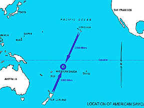 The
remote Territory of American Samoa is renowned for its scenic beauty, natural
deep-water harbor and friendly people. American Samoa is the only United
States possession in the southern hemisphere. It is located in the central
South Pacific Ocean, 2,300 miles south south west of Hawaii and 1,600 miles
east north east of New Zealand.
The
remote Territory of American Samoa is renowned for its scenic beauty, natural
deep-water harbor and friendly people. American Samoa is the only United
States possession in the southern hemisphere. It is located in the central
South Pacific Ocean, 2,300 miles south south west of Hawaii and 1,600 miles
east north east of New Zealand.
Deeded to the United States by the Samoan chiefs under a Treaty of Cession
in 1900, it is the only American possession to gain US protectorate status
without violent conflict. American Samoa is comprised of 7 islands of which
5 are volcanic and 2 are coral atolls.
The 5 volcanic islands, which are the major inhabited islands of American
Samoa, are Tutuila, Aunu'u, Ofu, Olosega and Ta'u. Tutuila, the largest
island, is the center of government and business. Aunu'u, a satellite of
Tutuila, lies 1 mile off the coast. The 3 islands of Ofu, Olosega and Ta'u,
collectively referred to as the Manu'a islands, lie 70 miles east of Tutuila.
Swains atoll with a population of approximately 30 lies 240 miles north
of Tutuila, and the uninhabited Rose Atoll is a 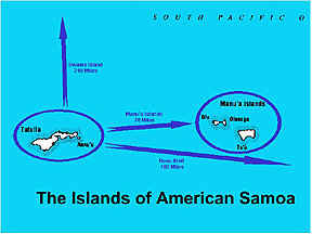 national
sanctuary preserve 180 miles to the east.
national
sanctuary preserve 180 miles to the east.
Sharp, steep inclines are the dominant feature of the main islands of American
Samoa. Razor sharp cliffs are the result of tectonic uplifts and volcanic
activity during the early formation period of the islands. These geographical
features cloaked in dense vegetation are a marvel of natural beauty second
to none throughout the Pacific. The total land area of American Samoa is
approximately 76 square miles. The largest island, Tutuila is 53 square
miles in size and is home to 92% of the territory's 65,000 residents. Tutuila's
natural deep-water harbor gave the islands their strategic value over the
past two centuries.
The people who live in the islands complement American Samoa's natural island
beauty. They hail from
a proud Polynesian seafaring people known as Samoans. American Samoans continue
to maintain their strong links to a unique culture that is based on hospitality
and a mutual respect for their fellow men and the environment. The local
inhabitants continue to enjoy and practice cultural rights and traditions
as guaranteed under the Deed of Cession with the United States.
 Approximately 95% of the landmass is held under the traditional land tenure
system and under the direct authority of the Samoan chiefs known as "matais".
Under this system, traditional land cannot be purchased or sold and the
current reigning chief from within the family unit has final say over the
disposition of a family's holdings. This system ensures the passage of assets
to future generations and serves as the catalyst in the preservation of
the Samoan culture.
Approximately 95% of the landmass is held under the traditional land tenure
system and under the direct authority of the Samoan chiefs known as "matais".
Under this system, traditional land cannot be purchased or sold and the
current reigning chief from within the family unit has final say over the
disposition of a family's holdings. This system ensures the passage of assets
to future generations and serves as the catalyst in the preservation of
the Samoan culture.
Rainfall averages 135 inches per year at the airport but varies greatly
over short distances because of topography. Pago Pago harbor with its
Rainmaker
Mountain located 9 miles north of the international airport receives approximately
200 inches annually while the crest of the islands receives well above 250
inches. In most years, the airport records about 300 days with a trace or
more of rain and about 175 days with rainfall of 0.01 inches or more. Temperatures
in the islands range between 73 and 93 degrees Fahrenheit and relative humidity
ranges between 73 and 84 percent throughout the year. The 5 main islands
of American Samoa exhibit rugged topographic relief. They rise precipitously
from the ocean and are covered with dense vegetation. The maximum elevations
for the major islands range between 1,621 to 2,142 feet. Deeply incised
stream valleys radiating from the summit of each distinct volcanic cone
provide natural drainage. Streams discharging at the heads of small embayments
have developed small coastal plains. In total, only 34% or 16,695 acres
of the land in American Samoa has a slope of 30 percent or less. Approximately
11,019 acres are located on Tutuila, primarily on the Tafuna-Leone Plain.
With a population of about 54,000, the population density on the main island
of Tutuila has reached an alarming 4.8 people per acre of arable land. American
Samoa's annual population growth rate in 1954 was 1%. In 1990 the annual
growth rate had reached 3.7%. With the exception of hurricane construction,
approximately 200 residential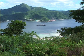 homes are built annually. Villages continue
to grow in size and limited agricultural land is fast being converted to
residential lands to accommodate expansion.
homes are built annually. Villages continue
to grow in size and limited agricultural land is fast being converted to
residential lands to accommodate expansion.
Narrow sand and coral rubble beaches rim approximately 25% of the coastline
wherever fringing reefs exist. Fringing reefs exist primarily on the calmer
south shore of the islands and on average extend out to sea approximately
200 feet. Exposed to severe marine erosion, the north shore coasts of the
islands are primarily steep volcanic cliffs that rise out of the ocean.
Proximity to the reef and salt spray exposure creates a highly corrosive
marine environment. This environment has caused the construction industry
in the territory to seriously reevaluate materials utilized in construction.
The expected useful life of standard metal guardrails is reduced by 50%
as a result of the salt air environment.